Blue Island · Cook County · IL
Homes for sale in
Blue Island.
- Active listings
- 24
- Median list
- $222K
- Avg time on market
- 19 days
- Sold · last year
- 94
Active listings
24 homes on the market


Be the first to know when a new Blue Island home hits the market
Text + email the moment a new listing matches.
About the community
Living in Blue Island.
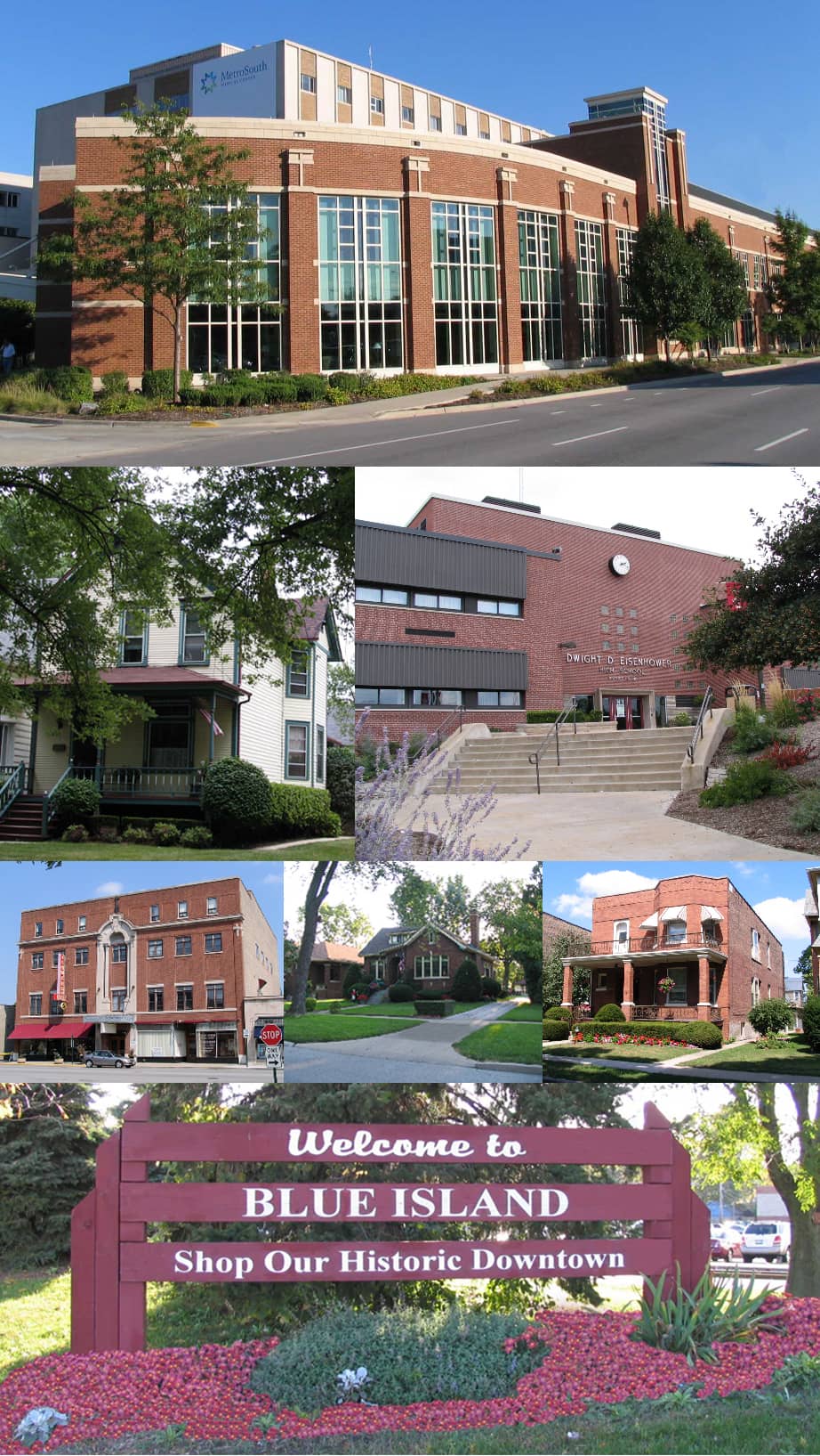
Blue Island sits on the literal glacial ridge that gave the city its name, rising above the surrounding lowlands 16 miles south of the Chicago Loop. The 4.16 square mile city is built around Western Avenue, the historic Vincennes Trail and Dixie Highway corridor that still functions as the central commercial spine. Two Metra lines serve the city: the Rock Island District at Blue Island Vermont Street (16.4 miles to LaSalle Street Station) and the Metra Electric Blue Island Branch at Burr Oak (18.4 miles to Millennium Station). The housing stock skews vintage, with brick Chicago bungalows, American Foursquares, and ornate Victorians lining Maple and Greenwood Avenues, many of them dating to the city's pre-1930 industrial era. A growing downtown arts community, anchored by the Blue Island Arts Alliance and the annual Mai Fest, gives the Olde Western Avenue Historic District a creative-class identity layered onto its working-class rail town roots.
At a glance
22,558 residents
2020 Census. About 4.16 square miles, of which 4.07 is land.
Two Metra lines
Rock Island District at Blue Island Vermont Street (16.4 mi to LaSalle Street) plus Metra Electric Blue Island Branch at Burr Oak (18.4 mi to Millennium Station). Six total Metra stations serve the city.
D130 + D218
Cook County School District 130 covers K-8 (Blue Island, much of Crestwood, parts of Robbins, fraction of Alsip). Eisenhower High School (District 218) in Blue Island for grades 9-12.
Incorporated 1872 / 1901
Settled 1836 by Norman Rexford. Village incorporation 1872, city charter 1901. Named for the wooded ridge appearing as an island above blue wildflower marsh.
Major Taylor Trail
6+ mile paved urban trail, named for African-American cycling world champion Marshall 'Major' Taylor. Runs from 81st Street to 134th Street, connecting Blue Island to Chicago's southwest side.
Olde Western Avenue arts district
Western Avenue between roughly 119th and Vermont Street: antique shops, art galleries, ethnic delis, Blue Island Beer Company, and the annual Mai Fest run by the Blue Island Arts Alliance.
I-57 corridor
Blue Island sits 0.25 miles west of I-57 and 0.5 miles east of the Tri-State Tollway. Western Avenue (IL-50) is the central north-south arterial.
Lower entry pricing
Median home value runs much lower than Cook County average. ZIP 60406 median was about $166,000 per City-Data. Detached homes can reach about $300K and low-rise brick condos start around $135K.
What’s close
Blue Island is a compact, walkable south-Cook city built around Western Avenue, with two Metra lines, easy I-57 access, and a downtown historic district that runs along Olde Western Avenue and Vermont Street.
- Olde Western Avenue Historic District
- The only stretch of the original commercial core left intact after the 1896 fire. Restaurants, antique shops, galleries, and the city's arts identity.
- Blue Island / Vermont Street Metra
- Rock Island District station, 16.4 miles to LaSalle Street Station. Also a transfer point onto the Metra Electric Blue Island Branch.
- Burr Oak Metra station
- Metra Electric Blue Island Branch, 18.4 miles from Millennium Station.
- Major Taylor Trail
- 6+ mile urban paved trail named for cycling world champion Marshall 'Major' Taylor. Runs from 81st Street south to 134th Street.
- Eisenhower High School
- District 218 high school at 127th and Sacramento. Founded as Blue Island Community High School in 1897. About 1,800 students.
- I-57 corridor
- The city sits 0.25 miles west of I-57 with the Tri-State Tollway 0.5 miles further west.
What it’s actually like to live here
Blue Island's day-to-day feel is shaped by walking distance: Western Avenue between roughly 119th and Vermont Street is dense with restaurants, bars, antique shops, art galleries, and ethnic delis, and most residents live within a short walk or drive of one of the city's six Metra stations. The Olde Western Avenue Historic District anchors the food and arts scene, with places like Blue Island Beer Company drawing visitors from across the south suburbs.
The housing experience is distinctly vintage: brick Chicago bungalows, American Foursquares, and ornate Victorians line streets like Maple and Greenwood, most of them on tree-shaded lots with detached garages off rear alleys. Memorial Park, Hart Park, and Centennial Park give residents pools, ballfields, and playgrounds within walking distance of most neighborhoods, while the Blue Island Arts Alliance's annual Mai Fest and ongoing public art projects give the city a creative identity layered onto its working-class roots.
Neighborhoods
Detailed Blue Island community pages coming soon.
Browse the listings above. Detailed neighborhood pages with market stats, school info, and lifestyle take-downs land here as we roll them out.
Schools
Districts serving Blue Island.
Boundary lines do shift. Always confirm in writing for a specific address before writing an offer.
- D130Grades K - 8
Cook County School District 130
Schools serving the area
- Whittier Elementary
- Lincoln Elementary
- Paul Revere Intermediate
- Veterans Memorial Middle
- Kerr Middle School
Serves K-8 for Blue Island, much of Crestwood, parts of Robbins, and a fraction of Alsip. Headquartered at 12300 Greenwood Avenue, Blue Island.
- D218Grades 9 - 12
Community High School District 218
Schools serving the area
- Dwight D. Eisenhower High School (Blue Island)
- Alan B. Shepard High School (Palos Heights)
- Harold L. Richards High School (Oak Lawn)
Blue Island residents attend Dwight D. Eisenhower High School in Blue Island, founded as Blue Island Community High School in 1897. District 218 was established in 1927.
Homes by school
Homes for sale by school in Blue Island
Around town
What there is to do in Blue Island.
A handful of the places people who live here actually use. Not a directory.
- Parks
Memorial Park
10.2 acre park at 12804 South Highland Avenue with two baseball fields, an outdoor pool, and a playground. Dedicated on Memorial Day 1922 on the site of the old Blue Island Cemetery.
- Parks
Hart Park
4.4 acre neighborhood park at 12325 South Western Avenue with a playground and softball fields. One of the city's most popular recreation spots.
- Parks
Centennial Park
10.5 acre park on the east side, originally acquired in 1935 and developed by the Works Progress Administration. Outdoor pool and playground.
- Parks
Major Taylor Trail
6+ mile paved urban trail named for African-American cycling world champion Marshall 'Major' Taylor. Connects Blue Island to Chicago's southwest side via the Forest Preserve.
- Culture
Blue Island Historical Society
Headquartered in the landmark Albee House at 13018 Maple Avenue. Documenting Blue Island history since 1971.
- Food & Drink
Blue Island Beer Company
Downtown craft brewery on Western Avenue with live music. Part of the Olde Western Avenue food and drink scene.
Getting around
Commute + transit from Blue Island.
- Stations: Blue Island - Vermont Street, Burr Oak (Metra Electric)
- Terminal: Chicago LaSalle Street Station
- Distance: 16.4 miles to downtown Chicago
- Routes: Western Avenue (IL-50) · I-57 (just east) · I-294 (Tri-State, just west) · Vincennes Avenue · 127th Street
- Chicago Loop: ~30 min
- Midway Airport: ~28 min
- O'Hare Airport: ~49 min
By the numbers
Blue Island taxes + market stats.
Property tax rates vary by exact township and assessor district. Confirm per address before pricing a purchase.
Property tax rate
3.16%
effective avg
Sales tax
11.00%
combined
Median sold price
$235,000
MRED · last 12 mo (94 sales)
Median household income
$59,489
ACS
How Blue Island got here
A bit of history.
Norman Rexford came from Charlotte, Vermont in 1835 and in 1836 became Blue Island's first permanent settler, establishing the Blue Island House near present-day Western Avenue and Gregory Street. The settlement was a way station on the Vincennes Trail, an old path connecting Fort Dearborn with Vincennes, Indiana. The name came from the appearance of the thickly wooded ridge crown, which looked like it floated in a sea of blue wildflowers above the surrounding marshland. Blue Island incorporated as a village in 1872 under first village president Benjamin Sanders and as a city in 1901.
Blue Island grew into a rail-junction working-class city with successive waves of immigrants: a large German population beginning in the 1840s, Italians from Basilicata and Calabria arriving at the turn of the 20th century and building St. Donatus Catholic Church in 1905, and later Polish, Swedish, and Mexican communities. The 20th-century anchor was St. Francis Hospital, opened in 1905, renamed MetroSouth Medical Center in 2008, and closed by Quorum Health in September 2019 after sustained losses. Lockwood Development Partners bought the property for $20 million in March 2020. Today the Olde Western Avenue Historic District is the surviving stretch of the old commercial core, with antique shops, art galleries, ethnic delis, and an active arts alliance hosting the annual Mai Fest.
The questions buyers actually ask
Blue Island FAQ
The questions I get most from buyers shopping Blue Island. If yours isn't here, text 224-385-8779, same-day reply.
- What does the name 'Blue Island' actually refer to?
- Blue Island sits on a glacial ridge that, to early settlers, appeared as a wooded island floating above the surrounding marshland. The thickly wooded crown of the ridge appeared to float in a sea of blue wildflowers, giving the town its name. There is no actual body of water.
- What Metra options does Blue Island offer for commuting into Chicago?
- Two different Metra lines. Blue Island / Vermont Street station is on the Rock Island District, 16.4 miles from LaSalle Street Station. Burr Oak station is on the Metra Electric Blue Island Branch, 18.4 miles from Millennium Station. The Vermont Street station also functions as a transfer between the two lines.
- Which schools serve Blue Island?
- Cook County School District 130 covers K-8 for Blue Island, much of Crestwood, parts of Robbins, and a small portion of Alsip, headquartered at 12300 Greenwood Avenue. High schoolers attend Dwight D. Eisenhower High School, part of Community High School District 218. Eisenhower was founded as Blue Island Community High School in 1897.
- What does the housing stock in Blue Island look like?
- Vintage and varied. Streets like Maple and Greenwood are lined with historic homes from the city's founding era. ZIP 60406 has a large stock of brick Chicago bungalows, American Foursquares, and brick ranch homes, many with detached garages off rear alleys. Detached homes can reach up to about $300,000, with low-rise brick condos starting around $135,000.
- What are property taxes like in Blue Island?
- The average effective property tax rate in Blue Island is approximately 3.16 percent per Ownwell's analysis, meaningfully higher than the Cook County average of 2.38 percent. This reflects the broader south Cook County tax burden.
- What is Eisenhower High School and why is it named for Eisenhower?
- Dwight D. Eisenhower High School at 127th and Sacramento is the District 218 high school in Blue Island. District 218 finished construction of the school in 1950, and on October 23, 1950, General Dwight Eisenhower, then president of Columbia University, personally spoke at its dedication. Eisenhower currently enrolls more than 1,800 students.
- What is the Major Taylor Trail?
- A 6+ mile paved urban trail that opened in 2007, named for Marshall 'Major' Taylor, the late-19th-century African-American cyclist who in 1899 became the first African American to achieve world champion status in cycling. It runs from 81st Street on its north end to 134th Street on its south end.
- Who is the real estate agent for Blue Island?
- Joe Keegan is the local licensed Illinois real estate broker who covers Blue Island in Blue Island, IL through Subdiview, a neighborhood-first home search for the Chicago suburbs and collar counties. Joe prices and negotiates from the live MRED sold comps for Blue Island specifically, not national averages, and can help you buy or sell here. Reach Joe at 224-385-8779 or joe@joekeeganhomes.com.
Nearby
Towns next to Blue Island.
If you’re cross-shopping the area, these are the places that border Blue Island.
Your local agent
Joe knows Blue Island
Most agents will list anything. I focus on the places I actually know, and the things that move value here don't show up in the MLS write-up: which streets and buildings hold demand, what the HOA or assessments really cover, how the comps read once you account for condition and location, and where buyers consistently want to be.
When you're ready to tour or list, you want someone who has read the last 50 closed comps in this specific market, not a national average, and can tell you what they actually mean for your price. That's how I work. Text or call any time, and I'll give you a real take, not a brochure.
- Licensed Illinois broker
- Comp-driven pricing
- Blue Island specialist
- Honest local market take
- Brokerocity
Thinking of selling?
What's your home actually worth?
Not a Zestimate. A real CMA from someone who's sold this neighborhood, knows the floor plan premiums, and can tell you which upgrades the buyer pool here actually pays for.
- Pricing range with comp-by-comp logic
- Pre-list improvements that pay back, and the ones that don't
- No obligation, no spam, no auto-dialer